For the last 4 years, we residents of Hastings Road in Waitsfield have been battling Vermont's Agency of Natural Resources (ANR) to prevent a 9-house subdivision, Conservation Designs, Inc.’s (CDI) Hastings Meadow, from being built. We have valid concerns that no one takes seriously. Especially ANR!
We have been through the Act 250 process, and appealed—only to lose because two of the individuals we were opposed to were allowed to rewrite the rules for Wastewater (Steve Revell) and for Act 250 itself (Adam Lougee). During the hearings, both even stated that they waited until the rules changed before offering their project for review. They neglected to mention they changed the rules!
When we offer testimony at the appeals hearing and in Environmental Court, Lougee’s partner Sandy Lawton offered verbal testimony in direct opposite of their submitted written testimony. Not once, but repeatedly!
We go into the judicial process with what seems a winning hand, but come out months later losing more than the original permits granted.
Why?
How about this:
1. The principals in the project, Conservation Designs, Inc. (V641430) are Shelburne attorney Adam Lougee (president, treasurer, and Director 1), and Sandy Lawton of Waitsfield (vice-president, secretary, and Director 2).
2. When Governor Jim Douglas announced his Act 250 reforms shortly after his election, the man sitting next to him, at his right hand as shown on WCAX-TV’s news footage—was Adam Lougee.
3. It is Adam Lougee’s name on the final Act 250 reform report.
4. CDI’s engineer, Steve Revell, was part of the committee updating the wastewater regulations in 2002. CDI applied for and was approved for their wastewater permit in January 2003. After the wastewater rules were rewritten—with the help of Steve Revell.
Isn’t that a conflict of interest on attorney Adam Lougee’s part to be “reforming” the Act 250 process while he has a project going through the Act 250 process himself as a developer?
For example:
We’ve been told by two different engineers, including the Verterre Group (engineers hired by the Hastings Road residents) that several of our wells will be compromised within two to five years of the project’s completion. Verterre Group outlined in detail how the engineering for the project is so flawed, including CDI’s engineers putting a mound system within a neighboring well shield (one that serves a family with two small children), that CDI’s permit should be revoked. Locating a 225-foot long mound system in someone else’s well shield is against regulations. However, Wastewater allowed them to request a waiver, years later, rather than have the plans changed.
One of the neighbors, an engineer himself, cited four pages of testimony to the Act 250 Board on how flawed CDI’s engineering was. During the hearings, Board member and professional engineer, Donald Marsh, stated that, “The appellants had successfully rebutted the wastewater permit.”
At that point, the Act 250 permit should have been revoked.
Yet, it wasn’t.
At the Environmental Board appeal level, the residents were granted party status for Stormwater Runoff issues as well as three other issues. CDI said they did the proper measuring for stormwater runoff and CDI’s figures came 4 square feet of runoff less than that which would trigger a permit.
Yet, calculations done by two other sources (engineers), taken from CDI’s own plans, showed they were hundreds of square feet over the trigger point. At the Environmental Board (EB) hearing, CDI stated their houses would have a 1400-square-feet footprint (for requested 2-story, 4-bedroom, 3,000 sq ft houses), plus 2-car garage and outbuildings times 10 lots, a 14-foot wide road which is clearly indicated at 18-feet wide on their submitted plans, so therefore, they were under by the necessary four feet.
Here are just two of the EB rulings (5W1418) in the list of findings [italics mine]:
53. CDI proposes to put in a new loop road at the end of Hastings Road to serve the Project. The loop road will be 14 feet wide to permit two-way traffic.
58. Road improvements include the removal of a ledge “hump” at Station 24, depicted on CDI Exhibit 3D at the very top of the road. Removal of the ledge and increasing the width of the roadway to 18 feet will reduce the grade and improve the line of sight.
If the road will be 18-feet wide, per #58—just one foot of it automatically triggers a stormwater permit.
But, it hasn’t.
If the Seasonal High Water Table testing had been conducted properly (March 1 through May 31), as is required, and the subsequent engineering done on real data, we residents would be more comfortable with the process. But the first time the developer (Lawton) and/or his engineer Gordon Reynolds were seen on the meadow during the testing season was in the middle of May of 2001. It is interesting that the engineer can’t find any field notes.
Lawton, who supposedly did the testing, in his testimony before the Act 250 Board and the EB contradicted himself every time he testified.
He has variously stated:
To the Act 250 Board in pre-filed testimony: In March 2001 (when the meadow in question was covered with 4 to 6 feet of snow), that “I skied in their tracks to the pipes.” But there was only one snowshoe track made by two neighbors nowhere near any of the test pipes.
At the Act 250 hearing: “It snowed every day, so it covered up my tracks.” According to the National Weather Service’s own records—it snowed 4 times. Tracks show, no matter how many times it snows.
At the EB hearing: “I used a neighboring road to access my pipes. I went at 4 o’clock in the morning so they wouldn’t see me.” He could drive to within 25 feet of the pipes on his own property. The neighboring road indicated would have required him to climb a steep, fallen-tree strewn slope, through 4 to 6 feet of snow to get to his pipes almost a ½ mile away. Ten of the pipes are in full view of neighbors living next to the meadow. The tracks would have been seen. There weren’t any.
During the entire month of March the fact remains—there were no tracks to any pipes on the

meadow. There are four witnesses who will testify to this, we who lived here and drove by the meadow daily. Or snowshoed on it three times. Incidently, our tracks always showed.
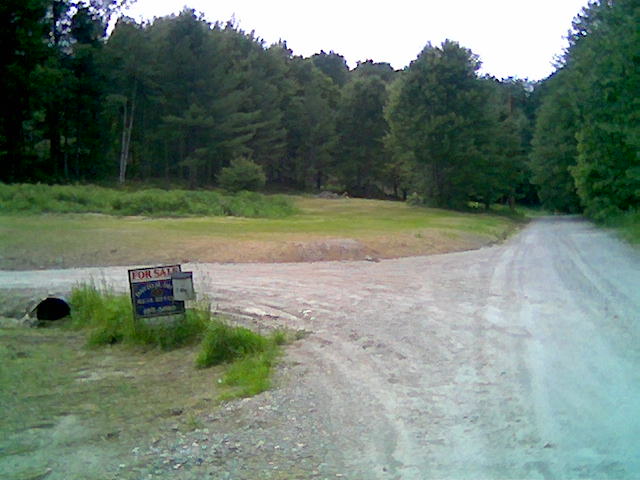
By April 28, 2001, there were no footprints to any of the test pipes as shown in photos taken that day. (The photo here was taken April 28, 2001 at test pipe 18 in front of lots 5-7 where septic is planned.) The photos were taken on negative film and processed the next morning. The original negatives show no footprints in any of 40 photos to any pipe. Yet the ground is patently wet, muddy, and in several cases, the pipes are surrounded by water. Lawton states he was there the day before with his engineer, Gordon Reynolds. In addition, if they had been there, their notes would have shown water in those pipes. But CDI’s data shows negligible water in any pipes. That year, even the 3 pipes shown swimming in water in the photos—passed on CDI’s data spreadsheet.
We brought this contradictory testimony to the EB’s attention—they couldn’t care less! Why? Because Lougee and Revell rewrote the rules. Revell’s engineering for this project is flawed, as well as being based on inaccurate data (no SHWT testing done at all). We proved that well enough that Don Marsh stated so during a hearing.
Yet—ANR let CDI get away with bad engineering, flawed design and truly unbelievable testimony.
And we citizens are to believe that ANR knows what it is doing? It was painfully obvious that ANR’s people never really bothered to check further into this at any stage of the process.